|
THE SOURCE Workbook Copyright © Nils Jansma 2008-2020, All Rights Reserved
CHAPTER 6 – THE LANGUAGE OF THE EARTH
Page 67 RELATIVE DATING; Steno’s Discovery q-67.1 For what is Nicolaus Steno famous?
Page 68 Examples of Limestone; Rock Formation q-68.1 How are the relative ages of the strata determined?
q-68.2 What environmental conditions are needed for the limestone to precipitate?
q-68.3 Based upon current tests, how long does it take to form one foot of precipitate-limestone?
q-68.4 What are the tree types of rocks found in earth strata?
Page 69 FOSSILS; Definition q-69.1 What is a fossil?
q-69.2 How do fossils form?
q-69.3 How complete is the fossil record for determining all the animals that have ever lived?
Page 70 Index Fossils q-70.1 What is an “Index Fossil?”
q70.2 What is “fauna or biotic” succession?
q-70.3 What do the exposed rock layers in the sides of the Grand Canyon reveal to us about the various environments that have existed at that location.
Page 71 Figure 6.1: Typical Index Fossils Used as Time Markers q-71.1 What conclusions could you draw if you found a rock with a “Bathyurus extans” fossil in it?
Page 72 Micro-evolution q-72.1 What is another word for micro-evolution?
q-72.2 What is macro-evolution?
q-72-3 Does the “fact” of evolution pertains to micro or macro evolution?
Page 73 THE GEOLOGIC COLUMN; Definition q-73.1 Upon what unscientific “extrapolation” does the modern theory of evolution depend?
q-73.2 What is the total estimated thickness of all the sedimentary rock strata on earth?
Page 74 Problem with Time q-74.1 Approximately, how long is it estimated to have taken to deposit 85 miles of sediment?
q-74.2 What mistake was made with regard o Usher’s estimate of Biblical chronology?
Page 75 RADIOMETRIC DATING; Definition; Carbon-14 Method q-75.1 What important tool is available for determining the absolute ages of rocks?
q-75.2 Why is the Potassium-Aragon method the most popular dating method?
q-75.3 What effects the accuracy of C-14 dating methods?
Page 76 Cross-Checking Continental Deposits q-76.1 What is the “upper limit” range for C-14 dating?
q-76.2 What is one method of cross-checking the accuracy of lava flow ages?
Page 77 Cross-Checking Seafloor Material q-77.1 What is an ocean’s spreading center?
q-77.2 How have age dating methods been cross-checked using “continental drift” movements?
Page 78 Figure 6.2; Seafloor Spreading
Page 79 Oxygen Isotope Ratios q-79.1 What is the O16/O18 oxygen ratio used for?
79.2 What are some earth-wide events that ocean cores record and why?
Page 80 Cross-Checking Polar Icecaps: Cross-Checking Milankovitch Cycles q-80.1 What were the findings of the Glomar Challenger’s 15 year data collecting project?
q-80.2 How can ocean and ice cap core data be cross-checked?
q-80.3 What would be proven if astronomical cycles could be shown to be related to the earth’s weather and deposition cycles? Page 81 Figure 6.3: The Milankovitch Cycles in Paleoclimate q-81.1 Describe the three “Milankovitch Cycles.”
Page 82 Examining Current Dating Methods q-82.1 What physical cross-checking evidence seems to support the “Milankovitch hypothesis?”
q-82.2 Why are past criticisms of radiometric dating methods no longer valid?
Page 83 q-83.1 What precautions should one take when reading material critical of the most accepted dating methods used today?
q-83.2 What alternative explanation is offered to support the “young earth” theory?
End of Chapter 6
Copyright © Nils Jansma 2018, All Rights Reserved
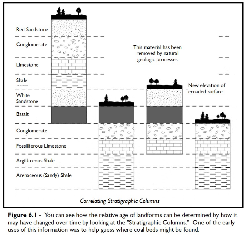
CHAPTER 6 – THE LANGUAGE OF THE EARTH Page 67 RELATIVE DATING; Steno’s Discovery q-67.1 For what is Nicolaus Steno famous? Nicolaus Steno observed that the exposed sides of some canyons looked like layers of stacked earth made of different materials. He surmised that these materials were originally deposited by water in a series of flat layers. This is called the “Principle of Original Horizontality.” By using common sense he developed a way to date the relative ages of the layers by assuming that the top layer was the youngest. This is called “The Principle of Superposition.” He also noticed the horizontal layers were found to extend for many miles sometimes separated by canyons where they temporarily disappeared only to reappear on the other side. He called this the ”Principle of Lateral Continuity.” Eventually his ideas were formalized into what have come to be called “Steno’s Laws.” Combining these principles, one can determine how the land has changed over time. See Figure 6.1. Page 68 Examples of Limestone; Rock Formation q-68.1 How are the relative ages of the strata determined? By estimating how long it takes to deposit a typical layer. By comparing how long it takes today, one can estimate that it took the same length of time in the past. This isn’t always reliable, but it is a start. Unless there is compelling evidence to the contrary, it is probably also accurate enough. q-68.2 What environmental conditions are needed for the limestone to precipitate?
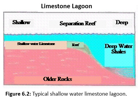
Limestone is a sedimentary rock, most often formed from ancient seashells and corals and other "limey" materials. Most limestone was formed in tropical to sub-tropical areas with sedimentation occurring in shallow waters of up to 50 feet deep. Limestone formation happens when, given a large number of years, layer resting upon layer causes solidification from shear weight. The texture of limestone is typically fine and often the shells that caused it's formation are clearly visible. It is the softest of the building stones used today, which makes it easier to work and therefore more affordable. Although limestone is usually available only in an unpolished state, some limestones are hard and dense enough to take a polish. Uses of limestone include flooring, fireplace surrounds, columns and furniture pieces. Through natural processes, limestone converts into marble when placed under extreme pressures and heat. You can easily detect limestone and marble by putting drops of hydrochloric acid on a sample. If it foams, it is probably either limestone or marble. Figure 6.2
q-68.3 Based upon current tests, how long does it take to form one foot of precipitate-limestone?
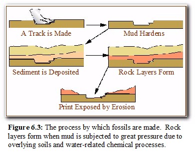
It takes approximately 2,250 years to naturally form 12 inches of shallow water limestone. However, there are examples of small areas forming much faster. These small areas are strongly influenced by tidal currents and weather. They are the exception rather than the rule. You would not want to apply this rapid formation criteria to a large area of thick limestone. q-68.4 What are the tree types of rocks found in earth strata? The three types are called, Igneous, Sedimentary, and Metamorphic rocks. They are all related to some extent. Igneous rocks form in the hot interior of the earth. Sedimentary rocks are generally made up of degraded Igneous, Metamorphic or other Sedimentary rocks. Metamorphic rocks are Igneous or Sedimentary rocks that have been subducted (driven under a continental plate into the hot semiliquid mantel region below) and changed by remelting into a different rock type with crystal structures like Igneous rocks. Page 69 FOSSILS; Definition q-69.1 What is a fossil? Fossils are the recognizable remains, such as bones, shells, leaves, or even tracks or burrows, all of which provide evidence and impressions of past life on Earth. Scientists who study fossils are called paleontologists. Remember that paleo means ancient; so a paleontologist studies ancient forms of life. Fossils are fundamental to the geologic time scale. The names of most of the eons and eras end in zoic, because these time intervals are often recognized on the basis of the animal life they contain. Rocks formed during the Proterozoic Eon may have fossils of relative simple organisms, such as bacteria, algae, and wormlike animals. Rocks formed during the Phanerozoic Eon may have fossils of complex animals and plants such as dinosaurs, mammals, and trees.
q-69.2 How do fossils form? http://www.discoveringfossils.co.uk/Whatisafossil.htm
If something living dies and is not subject to
normal decomposition, then it may become a
fossil. In general, fossils are rare because
nature usually recycles everything. We can
illustrate fossil formation by looking how a
dinosaur track may have been preserved. See
Figure 6.3.
q-69.3 How complete is the fossil record for determining all the animals that have ever lived? The November 19, 1998, copy of Nature Magazine gives some interesting information about how complete the fossil record is. In one respect, the record is very sparse when it comes to the actual number of specimens recovered. However, because of more sophisticated sampling techniques, a continuous record of earth’s relatively recent history has been derived from ocean and ice cores. A good example of this is ODP Site 926 on the Ceara Rise, western equatorial Atlantic. As far as can be told from biostratigraphy, it is said that this site has been sedimenting continuously for about 60 million years. Regular and gradual changes in the Earth's orbit that affect the chemical composition of sediments allows scientists to prove that there are no significant gaps whatsoever in the core record for the last 14 million years. This is strong evidence that the earth is ancient by anyone's reasonable standard.
Page 70 Index Fossils q-70.1 What is an “Index Fossil?” An Index Fossil is a unique specimen that doesn’t occur at any other time in the fossil record. It can be said with confidence that any deposit containing the same index fossil was lain down at about the same time no matter where it is located in the world.
q70.2 What is “fauna or biotic” succession?
Because index fossils change with time, they can be used as time markers. Related to this is the fauna or biotic succession that recognizes the changes to be more complex with each generation. They consistantly follow a pattern of succession from simple to complex.
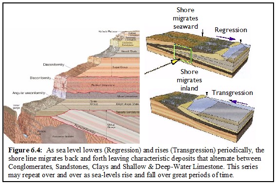
q-70.3 What do the exposed rock layers in the sides of the Grand Canyon reveal to us about the various environments that have existed at that location.
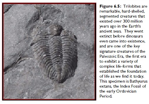
The sides of the Grand Canyon are made up of a series of rock types that are characteristic of what is called a Transgression-Regression cycle. Each layer of rock represents a completely different environment ranging from deep ocean water to conglomerates caused by inland and shoreline flooding. Figure 6.4 Page 71 Source Book Figure 6.1: Typical Index Fossils Used as Time Markers q-71.1 What conclusions could you draw if you found a rock with a “Bathyurus extans” fossil in it? You could conclude with reasonable certainty that the surrounding rock material was deposited during the Ordovician Period. This fossil has not been found in any other deposition Period and is considered an index or “Time Marker” fossil for the Ordovician. Figure 6.5
Page 72 Micro-evolution q-72.1 What is another word for micro-evolution? Another familiar word for micro-evolution is “adaptation.” All living things adapt to their environments over time or perish. Evolutionists have conveniently substituted the word "evolution" for the word "adaptation" which is very confusing. In other words today it could be said that your pet Pomeranian dog “evolved” from a German Spitz dog about 250 years ago. Why, because of “intelligent design.” Yes, a group of intelligent people in England miniaturized the German Spitz by cross breeding only the litter’s smallest members. Soon, a miniature Pomeranian breed arose because the original breeders were from Pomerania Germany. As a note of interest, today, Pomerania is a collective term used to refer to the three regions of Hither Pomerania, Farther Pomerania, and Pomerelia. It is located on the south coast of the Baltic Sea, and is divided between Germany in the west and Poland in the east by the Polish-German border.
q-72.2 What is macro-evolution?
Macro-evolution is large scale evolution for which there is no actual proof. The theory says that all species are related by common ancestors. We call this the "ameba to man" hypothesis. Macro-evolution has never been demonstrated in any laboratory. Even after using thousands of generations of experimental bacteria, an evolutionist would arbitrarily use the word "evolve" rather than "adapt" to account for such minor adaptive changes. q-72-3 Does the “fact” of evolution pertains to micro or macro evolution? The “fact” of evolution pertains only to micro-evolution. All of the modern day experiments that demonstrate species can be changed by outside influences is limited to micro-evolution. One of the most disturbing problems we have to contend with is how bacteria and viruses adapt to the antibiotics that have been developed to control them.
Page 73 THE GEOLOGIC COLUMN; Definition
q-73.1 Upon what unscientific “extrapolation” does the modern theory of evolution depend?
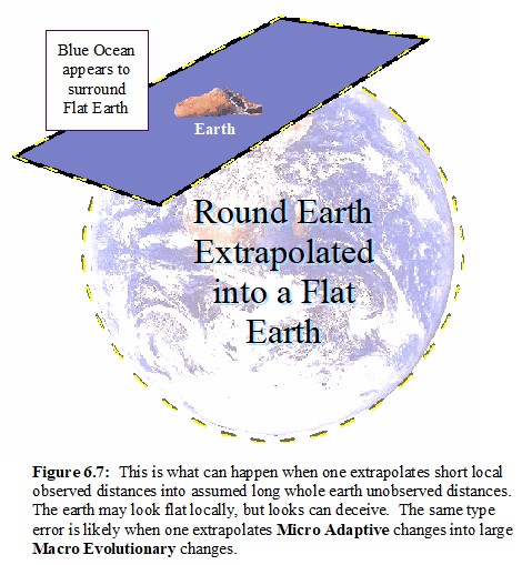
The extrapolation associated with micro and macro evolution. The supposition is that since micro-evolution can be factually demonstrated, then macro-evolution must be true by extrapolation. The extrapolation is that a little change in a short period of time automatically means a big change in a long period of time. However, there is more to this than that simple recitation. The primary basis for such an unfounded extrapolation is the opinion that there is no other explanation for how life has developed through time. It is true that if you assume that supernatural events cannot happen, than everything must be explained in terms relating to “natural” events. Therefore, macro-evolution must be true because it is the only act in town. Figure 6.6 illustrates how the original Flat Earth concept is nothing more than an *extrapolation similar to projecting short-term adaptive change into large scale evolution over long periods of time.
* Extrapolation: 1. To infer or estimate by extending or projecting known information. 2. Mathematics. To estimate (a value of a variable outside a known range) from values within a known range by assuming that the estimated value follows logically from the known values. (www.answers.com)
q-73.2 What is the total estimated thickness of all the sedimentary rock strata on earth? According to one source in 1981, the total accumulated thickness of all sediments is about 85 miles. This information has not been updated to our knowledge.
Page 74 Problem with Time q-74.1 Approximately, how long is it estimated to have taken to deposit 85 miles of sediment? The estimated time is about 530 to 550 million years. The start of this time is called the Cambrian Explosion. Up to this time, only single celled creatures existed. This period is believed to be the start of all the larger scale animals whose body types can be traced down to the present in one form or another. http://palaeo.gly.bris.ac.uk/Palaeofiles/Cambrian/timing/timing.html
q-74.2 What mistake was made with regard to Usher’s estimate of Biblical chronology?
Usher stated a number of limitations to be considered when using the Bible for computing the age of the earth. Unfortunately, his chronology speculations were placed in the margin of the King James Bible without any limiting qualifications. This led many people to think the dates were a part of the Bible’s text. Today, this has become a very controversial subject. However, such differences are based upon the translating sciences and not the physical sciences. So the time dispute is not religious because it is between two different scientific groups. When viewed in this light, neither side of the time issue is based upon faith in God alone. Therefore, we should not let such issues divide us. Page 75 RADIOMETRIC DATING; Definition; Carbon-14 Method q-75.1 What important tool is available for determining the absolute ages of rocks?
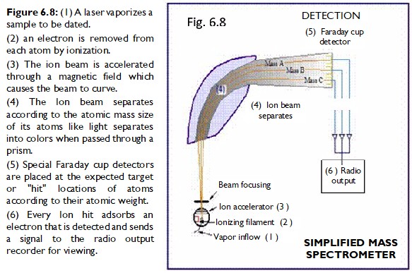
Steno’s relative dating was not capable of determining absolute dates. However, with the discovery of radioactivity, a new tool called radiometric dating was developed that could determine the absolute age of a rock or mineral since its formation. When rocks transform from a molten to a solid state, their atomic structure is locked into place as it cools. From this time forward, the rocks begin to change due to radioactive decay. The absolute age of the rock since it solidified can be determined by counting how many atoms changed due to radioactivity. The accuracy of radiometric dating has steadily improved since the Mass Spectrometer was introduced in the early 1950s as a measuring device. As a result, dating analysis can now be performed on samples as small as a billionth of a gram. Using a laser beam, the mass spectrometer operates by vaporizing the sample into a beam of ionized atoms. The stream of ions are directed to travel through a magnetic field, which selectively diverts them into a series of precisely targeted sampling sensors, known as "Faraday cups." On impact in the cups, the ions initiate a very weak electric current that can be measured to determine the rate of impacts and the relative concentrations of different atoms in the various sample streams. This device is so precise that it can actually count all the target atoms in a sample. See Figure 6.8 . q-75.2 Why is the Potassium-Aragon method of testing the most popular dating method? Because it is among the cheapest and easiest test to perform. How is the test conducted? Most solid rocks initially contain significant amounts of Potassium (K-40) but not much if any Aragon (AR-40) because it is a gas and quickly evaporates as the melted rock cools. However, when the rock solidifies, decayed Ar-40 will begin to accumulate in the crystal lattices of the rock. This is because the radioactive isotope K-40 decays into, among other things, Ar-40 with a half-life of 1.26 billion years. In order to determine the decayed Ar-40 content, the rock sample must be melted and the isotopic composition of the released gas measured via mass spectrometry. It is also necessary to separately measure the amount of K-40 by using a sample of the same rock with the same weight as that used for the Ar-40 determination. This can be done by flame photometry or atomic absorption spectroscopy. The ratio between the Ar-40 and the K-40 is related to the time elapsed since the rock was cool enough to trap the Aragon gas. q-75.3 What effects the accuracy of C-14 dating methods? Radio Carbon 14 dating accuracy has been greatly increased by the use of accelerator-based mass-spectrometric (AMS) techniques. This method allows all the C-14 atoms to be counted directly, rather than only those decaying during the counting interval allotted for each analysis. New calibration curves are continuously being produced as more data is accumulated. The 2004 version of the calibration curve extends back quite accurately to 26,000 years BP. Any errors in the calibration curve do not contribute more than ±16 years to the measurement error during the historic and late prehistoric periods (0 - 6,000 yrs BP) and no more than ±163 years over the entire 26,000 years of the curve, although its shape can reduce the accuracy at specific known time periods and, therefore, care needs to be exercised in its use. RADIOCARBON, Vol 46, Nr 3, 2004, p 1029–1058 © 2004 by the Arizona Board of Regents on behalf of the University of Arizona
Page 76 Cross-Checking Continental Deposits
q-76.1 What is the “upper limit” range for C14 dating?
The 2007 proposed radiocarbon 14 age dating limit now lies in a range between 58,000 and 62,000 years (approximately 10 half-lives). This limit is encountered when the radioactivity of the residual C-14 in a sample is too low to be distinguished from the radioactivity of the assumed 'dead carbon' blank samples used as background. This limit is subject to change as more accurate instrumentation is put into service. q-76.2 What is one method of cross-checking the accuracy of lava flow ages? By using both Radiometric dating methods and reasonable estimate of sedimentation rates, a correlation between the two methods can often be established. This is convincing proof of the accuracy of both techniques.
Page 77 Cross-Checking Seafloor Material
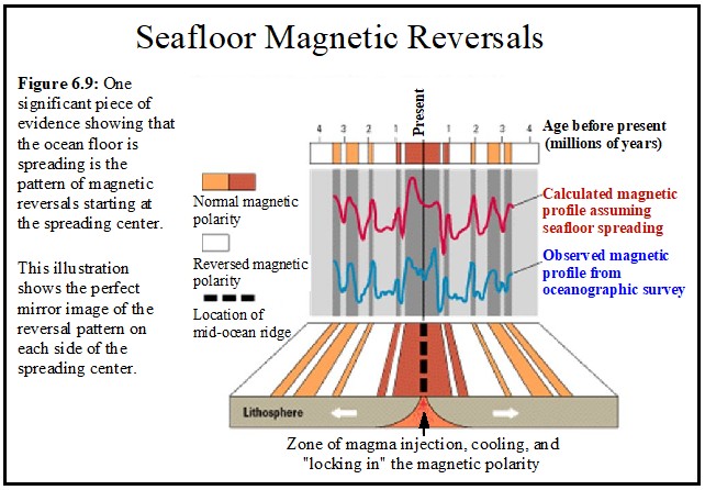
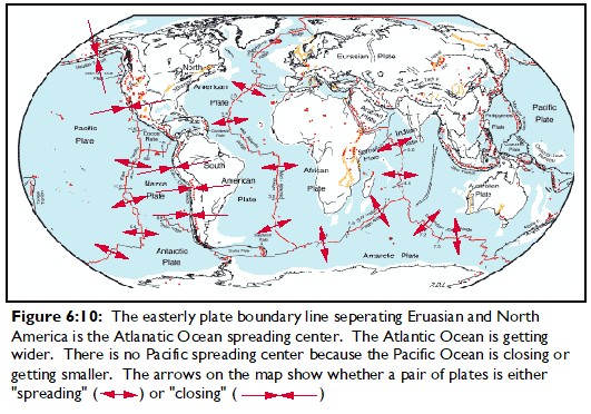
q-77.1 What is an ocean’s spreading center? “Spreading Centers” are associated with the geological study of “Plate Tectonics.” This theory, which has largely been proven in principle, subdivides the earth into several large scale moving sections or plates. When two of these plates separate, it is often due to what is called a “spreading center” as shown in Figure 6.2 in The Source textbook. Today we find spreading centers in the middle of some oceans. Sea borings and have confirmed the “spreading center hypothesis.” However, another method of proof is also available. Airborne geomagnetic surveys shows a strange pattern of symmetrical magnetic reversal bands on opposite sides of these ocean ridge spreading centers. (Figure 6.9) This magnetic banding directly corresponds to the Earth's past polar magnetic reversals. This fact was confirmed by measuring the ages of the rocks within each band. The magnetic banding furnishes a map in time and space of both spreading rates and polar magnetic reversals. Figure 6.10
q-77.2 How have age dating methods been cross-checked using “continental drift” movements? By determining the age of the rocks near the continent, one can determine about how long the ocean has been separating. This can be cross-checked by determining how thick the sediments are at that location. How long it took to deposit the sediments should agree with the age of the rocks supporting them. This age should also reasonably agree with the time it took for the continents to separate to their present locations. Page 78 Source Book Figure 6.2; Seafloor Spreading
q-78.1 What do we find at the boundary where one plate overrides an adjoining plate We generally find extinct and active volcanoes along with frequent earthquakes. This is especially noteworthy with regard to the Pacific plate. The boundary or continental margins around the Pacific Ocean are known as the “ring of fire” because of both earthquake and volcanic activity. Page 79 Oxygen Isotope Ratio?
q-79.1 What is the O18/16
oxygen ratio used for?
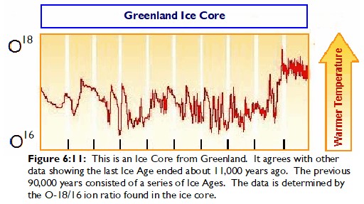
It is used for determining the earth’s past prevailing temperature. The Oxygen-18 and Oxygen-16 ratio is similar in principle to Carbon 14 dating. The same methods are used to test samples of calcium carbonate and other hard bodied fossils to determine the O-18/16 ratio prevalent at the time when the fossil creature lived. The ratio is larger in cold water than in warm. Just the opposite is true when we measure the ratio at the North Pole. In ice cores we find the temperature records established by the O-18/16 ratio to be complementary to those in ocean-bottom cores. In cold weather more of the heavy O-18 is left in the ocean with less being evaporated into the air. So the snow that falls at the Poles will have a smaller O-18/16 ratio in cold weather than found in the oceans. This is another interesting cross check to verify the accuracy of the findings. Ocean temperature clues can be obtained in other ways also. There are what is called right and left curling fossil shellfish. The right curling type lives in warm water and the left curling in cold. So research on these fossils are another means of cross checking the accuracy of the coring data. Figure 6.11 79.2 What are some earth-wide events that ocean cores record and why? The bottoms of the various oceans become the repository for the earth’s atmospheric content. When various events like volcanic eruptions or when asteroids hit the earth, the atmosphere becomes filled with debris which eventually falls on the surface of the ocean and sinks to the bottom. These events can be detected when the ocean core samples are analyzed. The same can be said of ice cores taken at the poles.
Page 80 Cross-Checking Polar Icecaps: Cross-Checking Milankovitch Cycles
q-80.1 What were the findings of the Glomar Challenger’s 15 year data collecting project?
The 60 miles of core samples taken over 15
years agreed with other data that puts the age of the
Atlantic Ocean floor rocks adjacent to the North West coast
of Africa and the East coast of the United States
to be about 200 million years old. q-80.2 How can ocean and ice cap core data be cross-checked?
By radiometric dating methods, core samples of ice and ocean ooze can be correlated. It is found that areas in a sample of ice and ocean cores that date to be about the same age contain similar atmospheric markers. These correlations provide convincing proof that the age-dating processes are very accurate.
q-80.3 What would be proven if astronomical cycles could be shown to be related to the earth’s weather and deposition cycles? Because astronomical cycles can be mathematically calculated based upon normal physics, any feature on earth corresponding to such a cycle must share its age. This relationship would indicate that the earth is very old because some relevant astronomical cycles have been determined to take hundreds of thousands of years. Page 81 Figure 6.3: The Milankovitch Cycles in Paleoclimate q-81.1 Describe the three “Milankovitch Cycles.”
As shown in The Source Figure 6.3, the Milankovitch Cycles consist of three features. These are, Eccentricity, Obliquity, and Precession. When all three of these cycles place the earth in a position that significantly reduces energy received from the Sun, an Ice Age occurs. The results of a detailed examination of deep-ocean cores shows that the cyclic ice age occurrences seem to be related to such astronomical cycles . These results were written up by Hays, Imbrie and Shackleton in the article, "Variations in the Earth's Orbit: Pacemaker of the Ice Ages", published in Science magazine. (Science, December 10, 1976, Vol. 194 no. 4270 pp. 1121-1132)
Page 82 Examining Current Dating Methods
q-82.1 What physical cross-checking evidence seems to support the “Milankovitch hypothesis?
Along with those items discussed in The Source, additional information has given support to the validity of the MC hypothesis. According to the 2008 Encyclopedia Britannica, “Considerable effort has been directed toward correlating climatic oscillations with perturbations in the Earth's orbit and rotational axis, which affect the solar energy reaching the Earth's surface.” Additionally, “The sedimentary cycles, dated by the magnetic polarity reversal time scale, were used to calibrate the astronomical time scale, which by 1997 had been established for the past 12 million years and appeared to be more accurate and have higher resolution than the other time scales. Research during the year was directed toward finding a correlation between marine and continental sedimentary sequences and extending the astronomical time scale to earlier times. These findings could lead to a better understanding of paleoclimatology and climate modeling.”
q-82.2 Why are past criticisms of radiometric dating methods no longer valid?
In the past, arguments challenging the accuracy of the dating methods appeared to have some validity. However, with the improvements of dating instruments and credible cross checking tests, it is difficult to invalidate the more recent tests. Additionally, independent competing testing laboratories come up with the same dates for the same materials. This cannot be considered accidental. When testing laboratories disagree, more detailed tests generally clarify the issue.
Page 83
q-83.1 What precautions should one take when reading material critical of the most accepted dating methods used today?
One should be sure the criticisms are based upon current information. Older tests have been erroneous but satisfactory corrections have been made using newer procedures. Radiometric Dating accyract has improved by quantum leapes within the last 30 years. This stresses the importance of checking the year when the radiometric dates being challenged were made. If it involves the years from 1950 to 1970, the material is likely outdated and should not be taken seriously. q-83.2 What alternative explanation is offered to support the “young earth” theory?
"Flood Geology" is often used by some as an alternative for explaining how the fossil record developed. In Appendix 7 of The Source, this theory is examined in detail. As a relevant comment using the material we have just considered, you might again review Figure 6.12 below. Notice that the drilled layers of ice date back to over 400,000 years. However, if the ice cap were completely submerged in water, it would have floated away and new ice would have formed in its place. Therefore the ice should be no older than 4 to 5 thousand years. It is also evident that the liquid lake under the ice cap indicates that there is an interface of unfrozen water lubricating the land surface supporting the ice cap. This may be caused by the earth's interior heat radiating to the surface. So, the ice cap is not "glued," so to speak, to the land surface and would easily float away if the ice caps were completely submerged. This should indicate to a reasonable person that the Great Flood of Noah did not cover the ice caps. While The Flood did occur as the Bible describes, one should never forget that there is no word in Hebrew for "planet earth." When the ancients referred to the "earth," they always meant the known area surrounding where they lived. This is well illustrated at Genesis 41: 56, 57. It should be apparent that the term "earth" used here does not refer to the whole earth but rather to the earth known to the readers of the Genesis account at that time. The famine spoken of did reach as far as the promised land and was the means by which God used to bring the Israelites down to the land of Egypt. How much farther the famine extended cannot be determined because there is no physical evidence of an earth-wide famine occurring at this time. We would be able to detect it through archeologically if such a world wide famine had occurred because much of the earth's population would have suddenly died. Genesis 41:56-57 (Modern King James Version) And the famine was over all the face of the earth. And Joseph opened all the storehouses, and sold to the Egyptians. And the famine was severe on the land of Egypt. (57) And all the earth came into Egypt to buy, to Joseph, because the famine was severe in all the earth. And the famine was over all the face of the earth:776 And Joseph opened all the storehouses, and sold unto the Egyptians; and the famine waxed sore in the land776 of Egypt. (57) And all countries776 came into Egypt to Joseph for to buy corn; because that the famine was so sore in all lands.776 Genesis 41:56-57 (KJV-Strongs) And the famine was over all the face of the earth:776 And Joseph opened all the storehouses, and sold unto the Egyptians; and the famine waxed sore in the land776 of Egypt. (57) And all countries776 came into Egypt to Joseph for to buy corn; because that the famine was so sore in all lands.776
H776 End of Chapter 6
Figure 6.12: After drilling through almost 4 kilometers of ice, they found Lake Vostok. Look at what they also drilled through on the way. Apparently, the ice has been accumulating for over 400,000 years.
|